From the Field: East

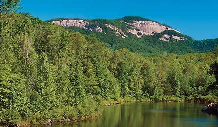
'Table Rock (Pat and Chuck Blackley)'

Table Rock (Pat and Chuck Blackley)

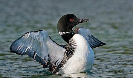
Look for Loons on Chase Lake (Tom and Pat Leeson)
Table Rock Trail, Table Rock SP, SC
Scott Stegenga, Pickens, SC
Scan a raptor flyway on this 6.8-mile out-and-back to a 3,124-foot Appalachian foothills summit. The route climbs 2,000 feet through a shady oak-hickory forest, but it saves the best for last, Stegenga says: Just beyond the summit, the trail ends at a granite gneiss shelf with a 180-degree vista into North Carolina. Watch here at midday for swirling kettles of migrating broad-winged hawks (peaking the third week of September) and a pair of resident peregrine falcons on the cliffs to the north. Trip ID940927
“Rest at the CCC lean-to at mile 1.8; from there, most of the work is behind you, and most of the views are ahead.”
Chase Lake Trail, Adirondack Forest Preserve, NY
Winnie Yu, Voorheesville, NY
Leave the peakbaggers behind on this six-mile out-and-back to a secluded lake in the shadow of 2,496-foot Pinnacle Mountain. “Even on a Sunday,” Yu says, “we saw no one.” From the trailhead, listen for barred owls as you tunnel through a low fern understory; continue through hemlock forest to a stream crossing at mile 2.4. From Chase Lake’s north shore at mile three, scan the water for the area’s iconic black-and-white speckled loons. Trip ID1227476
“Eat lunch at the log lean-to with lake views at mile three.”
North Turnhole Bend Trail, Mammoth Cave NP, KY
Larry Johnson, Mammoth Cave, KY
After your requisite cave tour, explore above-ground on this 6.9-mile out-and-back on a peninsula 200 feet above an oxbow river bend. “When the leaves fall in mid-September, you can see the Green River on both sides of the ridge for the last 1.5 miles,” Johnson says. Cross a 200-foot-wide choke point flanked by cliffs on both sides just before the tip of the peninsula (campsite here; free permit required); follow use paths down to the water’s edge. Trip ID10250
“You’ll see wild turkey scratching for nuts and acorns.”
Walls of Jericho, Skyline WMA, AL/TN
Kelly Stewart, Nashville, TN
Bring water shoes for creek crossings and wading on this descent into a 200-foot-deep, hardwood-shaded limestone amphitheater. Take the .5-mile Mill Creek spur at mile 1.3 to a 10-foot-wide seep hole spraying water into the creek below. “It’s the smaller of the hike’s two blowholes, but it’s more impressive because of its tighter circumference,” Stewart says. “The water shoots out straight like a firehose.” Continue two miles to the intimate amphitheater, where Turkey Creek forms a 35-foot waterfall; the sloped entrance to the mellower blowhole doubles as a slide. Trip ID334808
“Hike two days after a rain for best trail and falls conditions.”
Twin Summit Loop, Camden Hills SP, ME
John Christie, Camden, ME
Local secret: Tourist crowds wane between Labor Day and October leaf-peeping. Exploit the lull on this 7.8-mile loop just west of Acadia NP. From 780-foot quartzite Mt. Battie at mile 1.3, gaze across Penobscot Bay to 1,530-foot Cadillac Mountain. That’s just a warm-up for the views you’ll gain at mile 2.5, below the 1,385-foot summit of Mt. Megunticook. “Look directly west on a clear day and you’ll see Mt. Washington 120 miles away,” Christie says. Return past a recently rebuilt 1930s-era ski shelter. Trip ID 20772
“In fall, visibility improves because there’s very little fog.”