Published May 23, 2013 04:39PM
First Night Out: Water
Three beautiful water-side hikes
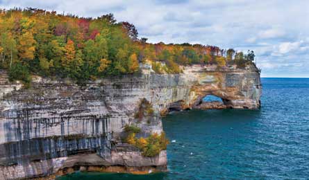
'Chapel Beach Loop, Lakeshore Trail (Willard Clay)'
Pictured Rocks National Lakeshore, MI
Chapel Beach Loop
Plenty of hikes lead to a spectacular waterfall, an unspoiled lake, or a white-sand beach. Few showcase all three—especially in a mere 6.5 miles of easy hiking, as does this Upper Peninsula gem. Set out through northern hardwoods on the Chapel Falls Trail to see the 60-foot cascade tumbling down a rock wall above pristine Chapel Lake at mile 1.3. Press on to Chapel Rock, a stone pedestal jutting from the mainland at mile 3.1, for views across Lake Superior; depending on the light, the waters below range from emerald green to Bahama blue. Continue on to Chapel Beach, a secluded stretch of sand tucked in a cove whose shallow waters warm to a swimmable mid-60s in high summer; six campsites sit in the hardwood-conifer forest a short dune climb above the beach. Claim a site, then follow the 1.5-mile spur west from camp to Grand Portal Point, where 200-foot walls of layer-cake sandstone line the water’s edge, evidence of 300 million years of sedimentary deposits. Fall asleep to the sound of lapping waves and the occasional wolf howling in the distance; day two, close the loop along the western edge of Chapel Lake.
Go August for the warmest water, September for fewer bugs and people Get there From Munising, go 13.9 miles east on CR 58 to a left turn on Chapel Rd. (gravel), then continue 5 miles to the trailhead. Permit Required; $5/person/night Map NCTA Grand Marais to Au Train Lake ($7, northcountrytrail.org) Contactnps.gov/piro
Cumberland Island National Seashore, GA
Parallel Trail
Escape the high-rise condos and beach shops lining much of the Atlantic Coast on this barrier island, where you’ll find wide, undeveloped beaches flanked by primordial maritime forest. Catch a ferry (reservations recommended, $20) from St. Marys to reach the island, where only 300 visitors are permitted each day. From the Sea Camp dock, hike 3.5 miles beneath live oak branches hung with Spanish moss en route to the backcountry Stafford Beach Campground. Head 500 feet east, cresting a sandy ridge to your first views of rolling dunes leading to the ocean. There, your most likely companions will be seabirds like oystercatchers and plovers and—at night from May through July—nesting loggerhead sea turtles. Next day, make it a loop by hiking back along the beach. Keep an eye out for the island’s 150 feral horses.
Go Summer for nesting sea turtles; September/October for mild weather and no crowds Get there From Jacksonville, take I-95 north 30 miles to St. Marys Rd. Follow 3.3 miles to GA 40 east; continue 5 miles to St. Marys St. The ferry departs one block west. Permit Required; $2/person/night Map USGS Quad Cumberland Island South ($8, store.usgs.gov) Contactnps.gov/cuisv
Dinosaur National Monument, UT
Jones Hole Trail
Lack of water for drinking and cooking bumps many canyon-country trips out of the beginner category: If you don’t have advanced water-scouting skills, you’re stuck hauling in a heavy load of your own supply. Not here: This 4-mile out-and-back leads to a bona fide oasis 1,000 feet beneath sunset-hued cliffs. Early Native Americans must have liked it, too—petroglyphs and pictographs on the rocks date to the Fremont people, who lived here more than 1,000 years ago. (Take the obvious 100-yard spur trail at mile 1.5 to see the etchings.) From the Jones Hole National Fish Hatchery, follow the pancake-flat trail along spring-fed Jones Hole Creek, tracing the bottom of a sandstone canyon in the shade of cottonwoods and box elders. Pitch your tent at one of the two sites at Ely Creek, then head west for the real treat: a 10-foot waterfall tucked in a cove so cool, a few Douglas firs grow in its microclimate. Refresh under the cascade or splash in the pool at its base (bring your suit). Got time for a longer hike? Continue 2 miles past camp to the banks of the Green River, snaking 2,500 feet below the surrounding escarpment. Tip: Bring a rod to catch dinner in Jones Hole Creek, which teems with trout from the hatchery upstream (Utah fishing license required).
Go May/June/September for moderate temps Get there From Vernal, follow Diamond Mountain Rd. 19.4 miles northeast. Turn east onto Jones Hole Rd. for 16.6 miles to the hatchery. Permit Required; free Map Trails Illustrated Dinosaur National Monument ($12, natgeomaps.com) Contactnps.gov/dino