Published May 23, 2013 05:46PM
First Night Out: Fauna
Three trails teeming with wildlife
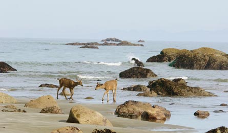
'Black Tailed Deer on the Olympic Coast (Tom & Pat Leeson)'
Olympic National Park, WA
Third Beach Trail
Animals don’t care about the view, of course. But it’s hard not to believe the abundance of wildlife along this mile-long stretch of shore doesn’t have something to do with the setting. Here, the Pacific meets the edge of the continent in startling fashion, with 200-foot sea stacks rising from the waves like giant tombstones and a 200-foot waterfall cascading off a rocky headland into the sea. This easy, 2.8-mile trip is your ticket to the zoo. Harbor seals park their pups on the partly submerged rocks just offshore in May and June, bringing orcas in search of a meal; that’s also the time to spot endangered sperm whales and gray whales spouting on the horizon. Sea otters and tufted puffins dabble on the water’s surface, while bald eagles soar overhead (especially in summer); black-tailed deer wander among tidepools filled with violet-shaded ochre sea stars and giant green anemones. A mostly flat trek through a hemlock and Sitka spruce forest will deposit you at this surf-pounded paradise. Up the solitude factor by heading north a half mile when you reach the beach to camp near the creek at its northern boundary. Camping is permitted anywhere on the beach—just be sure to pitch your tent well above the high-tide line.
Go May/June for whales and baby harbor seals Get there From Forks, take US 101 north 1.5 miles to a left on La Push Rd. Continue 11.5 miles to the trailhead. Permit Required; $5 plus $2/person/night Map BACKPACKER PRO Map Hoh River to Third Beach ($20, backpacker.com) Contactnps.gov/olym
Wichita Mountains Wildlife Refuge, OK
Charon’s Garden Trail
When North America’s once-millions-strong bison herd teetered on the brink of extinction at the turn of the 20th century, the Bronx Zoo sent 15 of the animals by train to this refuge in an effort to save the species. More than 100 years later, about 500 of the 2,000-pound beasts graze its mixed-grass prairie, which was spared the plow thanks to the patchwork of 500-million-year-old granite outcroppings littering the area. Camp smack in the middle of prime bison-spotting territory on this 4.8-mile out-and-back into the wilderness area at the refuge’s western edge, where your chances of glimpsing some of the refuge’s 600-member elk herd are equally high. From the Sunset trailhead, hike .5 mile to cross a dry drainage and reach camp in a rock-strewn valley, whose meadows offer the best odds for seeing bison—plus views east to 2,270-foot Elk Mountain (carry in extra water for cooking, as there’s no reliable water source here). Set up camp, then continue south on an easy scramble over, around, and under the house-sized rocks in a boulder field that would seem more at home at the foot of the Rockies than in southwestern Oklahoma. Retrace your steps back to camp when you reach the small lake at mile 2.4.
Go Spring for mild temps, September/October for bugling elk Get there From Lawton, take Cache Rd. northwest; it becomes US 62 west. Exit at OK 115 north. Continue on OK 49 west for 6 miles to the left turnoff for Sunset trailhead. Permit Required; $2/person Map USGS quad Quanah Mountain ($8, store.usgs.gov) or $4 map at visitor center Contactfws.gov/refuge/Wichita_mountains
Nahmakanta Public Lands, ME
Debsconeag Backcountry Trail
Only a few thousand visitors trek into this roadless section of the Maine woods each year, but those who do find glassy ponds laden with trout, unmarred mountain vistas, and—if they’re even a little bit lucky—some of the state’s antlered icons. Dozens of ponds, lakes, and bogs litter the landscape, providing prime habitat for moose, which outnumber deer here. This easy, 7-mile loop traces the eastern half of a figure-eight to a trifecta of moose hangouts: Beaver-dammed Stink Pond (near mile 2), tiny Seventh Debsconeag Pond (mile 4), and larger Sixth Debsconeag Pond (mile 5). The mixed hardwood-conifer forest opens up beyond Stink Pond for views across the rolling tablelands to 2,905-foot Jo-Mary Mountain. Pitch your tent on a ledge bordering Sixth Pond for your best moose-spotting odds at dawn and dusk; watch and listen for loons here, too. Late summer brings ripe blueberries to the rocky section leading up to Seventh Pond.
Go August to October for fewer bugs and fall colors (foliage peaks in early October) Get there From Greenville, take Lily Bay Rd. north to Kokadjo Trading Post. When the pavement ends, bear left at the fork and zero your odometer; follow signs for Nahmakanta Lake Camps and Debsconeag Lakes. Turn right at 1.8 miles. Turn left at miles 6.6, 14, and 18.4. Turn right at 19.3; park at 24.3 miles. Permit None required Map Trails Illustrated Baxter State Park/Mount Katahdin ($12, natgeomaps.com) Contact maine.gov