Published July 11, 2000 12:00AM
Desolation Wilderness, Eldorado National Forest
Behind the forbidding name lies California's glacier-polished playground.
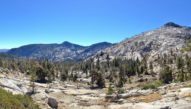
'Desolation Wilderness. Photo by: Miguel Vieira.'
Desolation Wilderness
Just west of Northern California’s Lake Tahoe is a remarkable landscape, mostly devoid of dense vegetation but overflowing with alpine lakes. Hikers climbing out of the densely wooded Lake Tahoe basin are often startled by the Desolation Wilderness’ sudden expanse of glacially polished scenery. It’s like being in an Ansel Adams photograph.
This 100-square-mile wilderness is small by most standards. A strong hiker could cross it in a day or two, but the treasures here encourage you to linger. The wilderness encompasses three mountain ranges and about 130 lakes (many stocked with trout). But be warned, Desolation’s excellent trout fishing and relative accessibility draw a lot of visitors, making some areas less than desolate.
ADVERTISEMENT
Desolation Valley is a 5-square-mile granite bowl. It once was filled with glacial runoff that spilled into the southern end of Lake Tahoe and washed through canyons before draining into the American River valley to the west. The glaciers disappeared 10,000 years ago, but the hard-edged granite gives the feeling that the Ice Age ended last week.
While visiting in late August, supposedly the warmest time of the year, my friends and I were chased out a day early by freezing temperatures and the threat of snow. We headed into the Velma Lakes region out of the Bay View Campground entrance point. Although the Velma lakes typically are crowded with fishermen and weekend wanderers, we managed to escape the crowds.
Heading toward Fontanillis and Dicks Lake, we found relative solitude and incredible scenery. Even on the most crowded of weekends, it’s possible to venture off-trail a short distance and set up a remote camp amid the granite bowls and high alpine lakes.
ADVERTISEMENT
Dicks Peak and Dicks Pass ~ at 9,380 feet, the highest pass on the Pacific Crest Trail between here and the Canadian border ~ are worthy destinations for the view alone. The trail to the top of Dicks Peak is obscure at times, but the scree-scrambling left us standing on top of the world, looking down on a windswept granite-colored kingdom dotted with hundreds of blue puddles.
Every paradise has its downside, though; its proximity to urban areas and the Tahoe recreation scene made the Desolation Wilderness crowded and scarred long before its wilderness designation in 1971. Hikers, four-wheelers, and cows all left their marks. Lakes were dammed and cattle still graze some areas. All things considered, however, the Forest Service is doing a commendable job of accommodating the heavy use and stemming the abuse.
Even though Desolation is a popular weekend destination, the northwest quadrant is the least used and can be explored cross-country for those proficient with map and compass. Plan a mid-week trip, if possible, or visit during winter and you’ll have a piece of this magnificent creation to yourself.
Desolation Wilderness Contact Information
Eldorado National Forest Information Center
3070 Camino Heights Drive
Camino, CA 95709
Call: (530) 644-6048
Lake Tahoe Basin Management Unit
870 Emerald Bay Rd.
South Lake Tahoe, CA 96150
Call: (530) 573-2600
ADVERTISEMENT
Taylor Creek Visitor Center
Call: (530) 573-2674
Location
Desolation Wilderness is in north-central California along the eastern border, 3-1/2 hours northeast of San Francisco, 2 hours east of Sacramento, and 1 hour southwest of Reno, Nevada. It’s bounded by logging roads and operations to the north and west, Lake Tahoe to the east, and US 50 to the south.
Getting There
Access Desolation Wilderness from I-80 or US 50.
Seasonal Information
This is a land of stark contrasts. Warm summer days, mild falls, and relatively low elevations belie the barren rock and harsh, windswept alpine winters and the sudden summer storms. Summer temperatures of 60 to 75 degrees F draw crowds in mid-June. In winter, the temperatures are in the high teens or 20s.
Wildlife
Deer, marmots, and a few bears make up the region’s wildlife.
Plant Life
Cedar, pines, firs, mountain grass, and wildflowers characterize the area.
Facilities
Camping is primitive in the wilderness area. Closest to the wilderness border is Bayview Campground (916 544-5994) to the east. It’s a free site with a 48-hour limit operating on a first come, first served basis. For information on campgrounds outside of the wilderness, call (800) 280-2267.
Parking
Contact the park office for information.
Permits
Deolation Wilderness operates under the U.S. Fee Demonstration Act. Contact the Eldorado Information Center in Camino for more permit information. Between June 15 and September 30, when a quota is in effect, overnight hikers should be sure to contact the Forest Service 90 days before their outing.
Policies
- There is a limit of 12 people per group.
- No campfires, motorized vehicles, or bicycles are allowed in the area.
Hazards
Be alert to extreme weather conditions.
Leave No Trace Policies
- Camp at least 100 feet from all water sources.
- Stay on trails to reduce erosion.
Maps
- A Guide to Desolation Wilderness is available from the Forest Service.
- The 15-minute USGS topo map Fallen Leaf Lake provides a view of most of the Desolation Wilderness area.
Other Trip Options
- Grab some maps for Granite Chief, Tahoe, and Robbs Peak if you want to venture beyond the most accessible trailheads or turn your hike into more than a weekend excursion.
- Or explore El Dorado National Forest’s other wilderness area, Mokelumne Wilderness.
- Mt. Rose is a newly established wilderness area in Nevada, northeast of Lake Tahoe. For more information, contact:
Carson Ranger District
1536 S. Carson St.
Carson City, NV 89701
(702) 882-2766
ADVERTISEMENT
Little Known Fact: Desolation Wilderness is the most heavily used wilderness area per acre in the United States.