Published October 21, 2008 06:34PM
Cold War: A Winter Traverse of New Hampshire's Presidential Range
Got guts? Good. Now learn what skills you'll need to bag America's Little Everest—a traverse of New Hampshire's Presidential Range—in winter.
'Mt. Washington's humidity makes temps feel ten clicks cooler.'
The Hike
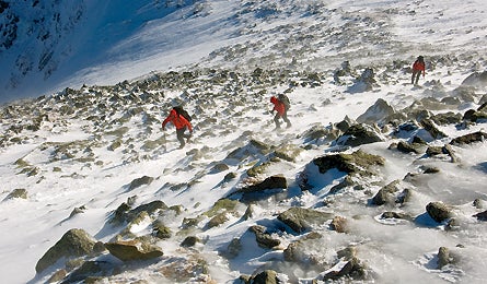
A winter traverse of the Presidential Range is the most coveted–and riskiest–mountaineering
feat in the Northeast. The 23.3-mile route includes 11 miles above treeline,
10,000 feet of elevation gain, and 10 peaks above 4,000 feet. Rime ice, massive
drifts and cornices, and fierce winds combine to create an amorphous landscape–a
cubist masterpiece, painted entirely in white. From the Valley Way Trail, you’ll
gain 3,500 feet in the first 3.8 miles, reaching the base of 5,366-foot Mt.
Madison (kick steps up another 557 feet to the summit if winds are calm). From
here, the route arcs counterclockwise past Mt. Jefferson and over Mt. Clay to
Mt. Washington, completing the northern half of the trip. Take the Crawford
Path down to the Lakes of the Clouds Hut to camp (pitch your tent a quarter-mile
away from the hut and the lakes). The next day, weather willing, you’ll snowshoe
or crampon seven exposed miles over Mts. Monroe, Franklin, Eisenhower, Pierce,
Jackson, and Webster as you drop more than 5,000 feet to the Crawford trailhead.
From Jackson’s summit, gaze back on your route; from Webster, look down into
Mt. Washington Valley, where beer, burgers, and a warm barstool await.
The Crux
Rapidly changing, extremely cold weather. Winds across this range exceed 100
mph one out of every four winter days.
The Key
Break the traverse into pieces, making realistic judgment calls at each junction
on the way. Michael Walsh, the Appalachian Mountain Club’s Pinkham Notch Visitors
Center Supervisor, says that while there are 11 wicked-exposed miles above treeline,
potential escape routes (Jewell Trail, Lion Head, Ammonoosuc Ravine Trail, and
Edmands Path, in that order) appear every one to two miles. He suggests stopping
at each of these junctions to gather your group together, evaluate weather and
team conditions, and decide whether to move forward or bail. In the event of
a sudden whiteout, rope up with your partner (with about 30 feet of rope between
you) and send him or her forward to sweep for the next cairn. Then advance like
an inchworm from cairn to cairn. Time your trip for one of the last six weeks
of winter: Days are longer (about 12 hours of daylight), sub-zero lows begin
to subside after mid-February, and the snowpack is harder (better for cramponing).
The Way
From Randolph, drive 1.5 miles west on NH 2 to the Valley Way parking area.
The Valley Way Trail starts at the lot’s west end. After the hike, pick up your
shuttle car at the AMC’s Highland Center, about 10 miles east of US 3 on US
302.
Plan It
Call the Appalachian Mountain Club’s Pinkham Notch Visitors Center (603-466-2721)
for current conditions. Use the AMC’s White Mountain Guide ($25; AMC Books)
and its maps. Check wmgonline.org
for an online subscription-based version.