Published May 24, 2010 04:59PM
Canyon: Narrows of the Virgin River, UT
Hike, swim, and scramble in this 16-mile slot canyon route.
'may 2010 zones narrows 200x170'

Hike, swim, and scramble your way through a 2,000-foot-deep sandstone gorge in the heart of Zion National Park. The Virgin River runs clear and cold here, cutting through world-class redrock terrain, visually striking maple glades, and fiery monkeyflower blooming out of narrow cracks in the canyon walls. The 16 soggy miles can be trekked as a long dayhike, but beware: Many overconfident hikers find themselves struggling to finish in chilly evening temperatures and near-darkness .
Navigation is not the hard part—just follow the river—but it’s easy to waste time by taking inefficient routes around boulders and pools. To move faster, and lessen the strain on knees and ankles, always follow the easiest, shallowest channel (typically at the sides), and avoid deep pools and strong currents around obstacles—especially in sandy areas. Caution: Weather and season dramatically influence water levels; rangers won’t issue permits in flows over 120 cfs (highest flows: April and May). If high water strands you in the Narrows, don’t try to fight it; stay put until levels drop.
ADVERTISEMENT
INFO 40 dayhiking permits ($10/1-2 people) available by walk-in only less than 24 hours prior to trip; reserve campsites up to two months in advance. River conditions: (435) 772-3256; nps.gov/zion. Trip data: backpacker.com/hikes/477517
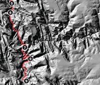
1. Chamberlain Ranch trailhead
0337199E 4139132N; mile 0
Hike southwest on the graded, riverside road for three miles and wade into the Virgin River. Keep maps handy and dry .
2. The Squeeze
0329675E 4137765N; mile 6.5
Canyon narrows to 20 feet. Probe pools with a hiking pole to test depth, and stick to the edges, where water is generally shallower.
3. Whitewater Obstacle
0328435E 4137232N; mile 7.5
A 20-foot-high waterfall over a logjam slows progress. Detour by climbing left/south through a crack behind a house-size boulder.
4. Deep Creek
0327132E 4136528N; mile 8.7
Water volume triples. Hike .6 mile downstream to small but aesthetic NPS Campsite #5, and sleep overlooking the river.
5. Goose Creek Confluence
0326726E 4134163N; mile 10.7
Steep, slick detour trails around boulder piles, deep pools, and cliffs can take up to two hours in this .75-mile section.
6. Big Springs
0326634E 4133392N; mile 11.3
Below the spring and waterfall (check out the hanging monkeyflower gardens), the gorge is flooded wall to wall. Expect to swim in places, with only gravel bars for respite over the next two miles.
7. Mouth of Orderville Canyon
0327476E 4130804N; mile 13.3
Dayhikers often crowd the canyon at the hike’s more accessible end, but the gorge remains spectacular, with walls towering a thousand feet overhead. Here, your pace quickens, with knee- to thigh-deep wading and long sections of easy riverside trail.
8. Deep Water
0327655E 4129923N; mile 14.6
Avoid a swim by veering river right. Stay close to the canyon wall, where you’ll find the shallowest passage (though the water can still be waist- to chest-deep).
9. Temple of Sinawava
0327339E 4128290N; mile 16
Take the asphalt tourist trail .75-mile to Temple of Sinawava’s soaring 3,000-foot walls. End at the parking lot/shuttle stop.
Canyon Bound
See more canyon hikes.