Updated December 3, 2024 08:28PM
Canyon: Davis Gulch, Glen Canyon National Recreation Area, UT
This picturesque Utah hike features natural arches and ancient petroglyphs.
'may 2010 zones davis 200x170'

If you measure hikes by jaw-dropping moments, not distance, you’ll lose count by the second bend on this 14.5-mile classic. (Like what you see? Try this .) You’ll traverse Navajo sandstone domes and open slickrock before descending into a wash filled with sagebrush, yucca, and snakeweed.
Fill a memory card with shots of natural arches and ancient petroglyphs, and camp below stunning alcoves. This area has also been the setting for a few mysterious disappearances: A pre-Columbian civilization abandoned the place 700 years ago; and Everett Ruess, an enigmatic artist and wanderer, vanished here in 1934.
INFO Get free walk-in permits at the Escalante visitor center: (928) 608-6200; nps.gov/glca. Trip data: backpacker.com/hikes/12099
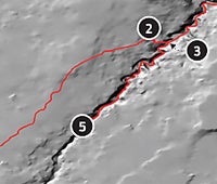
1. Hole-in-the-Rock Trailhead
0501221E 4123445N; mile 0
Head north on approach trail that parallels Davis Gulch. Behind you, the 50 Mile Bench borders a vast scrubland.
2. Enter Davis Gulch
0504114E 4128343N; mile 4.0
Turn right onto abandoned stock trail (look for cairns) and descend steep slickrock to a well-worn path.
3. Finding Nemo
0504390E 4128219N; mile 4.3
The remains of a corral mark the final known campsite of Everett Ruess, who scraped “Nemo” (Latin for “no one”) into surrounding canyon walls 76 years ago—and then disappeared.
4. LaGorce Arch
0505494E 4129283N; mile 5.5
Scramble around tiny waterfalls that nourish the lush riparian environment, and stand in the shadow of LaGorce Arch.
5. Bement Arch
0503120E 4126356N; mile 8.5
Pass by 400-foot-high alcoves to reach this locomotive-size arch, the end of navigable terrain. Backtrack six miles to trailhead.

Canyon Bound
See more canyon hikes.