Updated December 4, 2024 12:12AM
Best Hikes Ever: The Needles Traverse, CO
Forge your own route through the Rockies' most rugged corner.
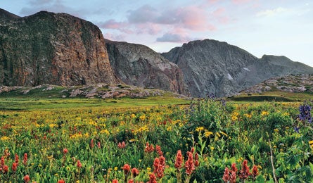
'Indian Paintbrush carpet the valley north of Elk Creek (Glenn Randall)'
| BEST HIKES EVER HOME |
Solitude and altitude in equal measure were what Steve Howe sought when he linked up this 50.5-mile, south-to-north route across the Needle Mountains in 2007. The passage along the southwest edge of the Weminuche (Colorado’s largest wilderness) is “not a route for the lazy or unacclimatized,” says Howe. “You’ll wander up and down through a succession of steep passes, rarely dropping below 12,000 feet.” But for your effort, you’ll explore historic mining ruins, roam wildflower meadows, and get up-close views of several Fourteeners—including the shockingly craggy Sunlight Peak—that few hikers ever see.
Do it
Allow at least a week. Follow the Endrich Mesa Trail (#534) north and then link: 12,800-foot Trimble Pass; Columbine Lake; Hazel Lake (a scenic camp); Vallecito Creek (mile 20; it runs knee-deep when water’s low); Sunlight Lake; 12,186-foot Verde Lake; then Blair Gulch, at 46 miles; and then down to Silverton.
Resources
Driving From Durango, take S. 15th St. to Florida Rd. and go 13.8 miles. Turn left on County Rd. 2431/FR 596, then a quick right onto high-clearance FR 597 and continue 10.6 miles to the parking area at Endlich Mesa trailhead.
MapsUSGS quads Columbine Pass, Storm King Peak, Howardsville, and Silverton
Contact (970) 387-5530; fs.fed.us/r2/sanjuan
Trip ID43747