Published January 25, 2008 11:21AM
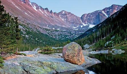
Backpack Rocky Mountain National Park
Try this 30-mile lollipop loop that is almost entirely above 9,000 feet.
'Longs Peak/Mills Lake, Dave Svilar'
We’re all for solitude in the wilderness, but some places are so great we don’t mind joining the crowd. Rocky Mountain, with three million visitors a year, is one such mecca—and this 30-mile lollipop loop is a greatest-hits tour. It winds north around Battle Mountain, one of the park’s 60-plus named peaks over 12,000 feet. It slices through one of RMNP’s biggest glacial valleys, rambles past some of its 450 miles of streams, then careens south and up the park’s high point, 14,259-foot Longs Peak. And get this: You’ll spend nearly the entire trip above 9,000 feet, listening to bugling elk (if you time it right) and gazing at 1,000-foot rock faces.
From the 9,400-foot Longs Peak trailhead, follow the flat Chasm Lake Trail for .3 mile, then turn right onto the Storm Pass Trail. The gentle grade winds through a dense evergreen forest for about 2.5 miles until it pops you into a clearing. On your right is Estes Cone, an inactive, scree-sided volcano. Take the 750-foot side trail to the top of the cone for bull’s-eye views of Longs, 13,911-foot Mt. Meeker, and the rest of the expansive range. Continue on Storm Pass roughly 3 more miles and turn right on the Wind River Trail to follow the wide, clear river .75 mile to your first campsite.
The next day, backtrack to Storm Pass Trail and turn right past the Glacier Creek and Boulder Brook intersections toward Prospect Canyon, an abrupt gorge carved by retreating glaciers. At the Glacier Gorge Junction trailhead, the path begins to climb out of the forest, meandering to Alberta Falls, an impressive display of snowmelt and gravity.
ADVERTISEMENT
Push past the falls into Glacier Gorge, where peaks tower over the trail and a vibrant mural of grasses and wildflowers sprout from the rock wall. Drop your pack at the designated campsite, hang your food, then dayhike several miles up the trail to a trifecta of glacial lakes cradled in the rocky kettles at the base of Longs, which shoots up to the east.
Day three holds a 10.8-mile trek to the Boulder Field, the staging ground for the classic Keyhole route to Longs’s summit. Eat, relax, and hit the sack early—you’ll need energy for day four’s predawn alpine start.
Climb west from your Boulder Field campsite to the Keyhole and follow the yellow and red markers. Make your way across the steep ledge system on the west face, then plunge forward into the Trough and squeeze your way over ledges called the Narrows. Take a deep breath of cold, thin air and reach for the summit. You’re 1.5 miles—and 1,655 vertical feet—above camp. The views are hypnotic, but head down before the all-but-guaranteed afternoon thundershower. It’s about four hours round-trip, and you may need crampons and an ice axe into midsummer.
ADVERTISEMENT
Your final day drops 3,200 feet over 6 miles back to the trailhead, where you’ll nod in approval at other hikers gearing up for the same excellent adventure. Sometimes great minds really do think alike.
Permits Mandatory ($20). To snag a spot at the Boulder Field, reserve by phone (970-586-1242) before May 15.
Guide/Map Hiking Rocky Mountain National Park, by Kent and Donna Dannen ($15, Falcon). Couple it with Trails Illustrated #200, Rocky Mountain National Park.
Reward Belly up for a Longs Peak Raspberry Wheat at Estes Park Brewery. epbrewery.com