Updated December 4, 2024 01:51AM
America's Best-Kept Secrets: Lake Chelan-Sawtooth Wilderness, WA
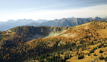
'Horshoe Basin, from Oval Pass. (Kirkendall-Spring)'
→ In An alpine park that’s as scenic—but not as stormy—as its famous neighbor
← OutNorth Cascades National Park’s fickle weather
Hike the east side of the Cascade Range, and you’ll discover jagged skyline views that equal those on the more crowded west side—and that aren’t obscured by a near-daily dose of cold, pounding rain. This four-day, 32-mile traverse from the tiny village of Stehekin to Prince Creek Campground (both on Lake Chelan) begins with a relentless, 5,700-foot climb on the Purple Creek Trail to Purple Pass. Camp at Lake Juanita after 7.3 hard-earned miles. For the next two days, follow the Chelan Summit Trail below the craggy Sawtooth Range; you’ll likely see more black bears than people (our Northwest Editor notched daily bruin sightings). The rugged trail pays off with views of Glacier Peak and the North Cascades across 50-mile-long and two-mile-wide Lake Chelan, which sits at the bottom of a trench 2,000 feet deeper than the Grand Canyon. Bridges— including a critical one across Prince Creek, which cannot be forded—receive infrequent maintenance; call the Chelan Ranger District before heading out. Local knowledge Best campsite: the stream-cut wildflower meadows of Horseshoe Basin at mile 16.5
Do it Take the Lady of the Lake ferry across Lake Chelan to Stehekin Campground (509-682-4584; ladyofthelake.com). The Purple Creek Trail begins behind the visitor center (pick up a free backcountry permit here).
Maps Green Trails Stehekin, Buttermilk Butte, and Prince Creek ($6 each, greentrailsmaps.com)
Guidebook Backpacking Washington, by Douglas Lorain ($18, wildernesspress.com)
Contact (509) 682-4900; nps.gov/noca
GPS data backpacker.com/lakechelan