Published May 22, 2009 06:17PM
America's Best Day Hikes: Southwest
From canyons to rock art to waterfalls, the Southwest has an abundance of natural beauty.
'Bryce Canyon's Sunset Point (Chuck Haney)'

Bryce Canyon’s Sunset Point (Chuck Haney)

Zion’s Subway slot (David H. Collier)
WEST | ROCKIES | SOUTH | SOUTHWEST | NORTHEAST | MIDWEST
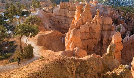
Wildest Geology
Navajo/Queens Garden Trails, UT 3 miles (Easy)
Get life-list scenery for stroll-in-the-park effort on this classic Bryce Canyon hoodoo tour. A hike starting from Sunset Point and connecting the Navajo Loop with the Queens Garden Trail coasts past hundreds of these sedimentary pillars, some reaching 150 feet high. The hoodoos have been compared to church steeples, castle walls, and even poodles. Best time to see them: after a rain- or snowstorm, when the oranges and reds appear even more vibrant than usual, or under the otherworldly light of a full moon.
Season Year-round
Infonps.gov/brca
WATERFALLS
Ice Box Canyon, NV 3 miles (Moderate)
Cool off here on the hottest day: This deep canyon, with its steep walls and reliable breezes–and secret waterfall–is always cooler than the surrounding desert in the Red Rock National Conservation Area. The short out-and-back is scrambly, with a final stiff climb that leads to a waterfall freefalling off a sandstone cliff. Here, you’ll find a bathtub-size pool perfect for a dip before the turnaround.
Season October-June
Infoblm.gov/nv
Calf Creek Falls, UT 5.5 miles (Easy)
This swimming hole comes with a side of prehistory: The out-and-back route winds past two ancient granaries and a Fremont Indian pictograph at the outset, then heads into the narrowing Calf Creek Canyon. Soft sand makes the going slow, but it’s less than three miles to Lower Calf Creek Falls, which plunges 126 feet from mineral-streaked Navajo sandstone–into an inviting almond-shaped pool.
Season April-October
Infoblm.gov/ut
Best Bushwhacking
Bowl of Fire, NV 7 miles (Difficult)
You’ll need solid navigation chops to wander in this desolate landscape of flaming-red sand, green limestone, and mazelike canyons, but the rewards are worth it: hidden rock arches, a “waterfall” of coarse gray limestone, and polished blue stones decorating the desert floor. Head north from the trailhead in Lake Mead National Recreation Area, aiming toward the base of Peak 651 for a mile, then swing northwest into Callville Wash to access the Bowl of Fire. Rule of thumb: Head downhill in any wash to reach Callville again.
Season October-May
Infonps.gov/lame
WEST | ROCKIES | SOUTH | SOUTHWEST | NORTHEAST | MIDWEST
ADVERTISEMENT
ROCK ART
Agua Fria River, AZ 4-12 miles (Moderate)
This hike is a two-fer: great rock-hopping in a petroglyph-packed canyon. Rock art in the recently designated Agua Fria National Monument isn’t as splashy as some, but you won’t have to share it with crowds, either. Hike out-and-back down Badger Springs Wash to the Agua Fria River (look for a panel at the canyon junction), then head downstream. Expect countless river crossings and some easy bouldering; there’s no maintained trail.
Season October-May
Infoblm.gov/az
Jones Hole Trail, UT 8 miles (Moderate)
Dinosaur National Monument’s best-kept secret? Two massive Native American rock art sites in Jones Hole Canyon, representing 7,000 years of human history. The creekside round-trip descends into a 2,000-foot-deep gorge; look for panels at Deluge Shelter, at mile two, and on the west bank of Jones Hole Creek just past the footbridge at mile four.
Season March-October
Infonps.gov/dino
WEST | ROCKIES | SOUTH | SOUTHWEST | NORTHEAST | MIDWEST
ADVERTISEMENT
CANYONS
Zion Narrows, UT 16 miles (Difficult)
For thrill-a-mile hiking, nothing beats this world-famous slot canyon: You’ll scramble over boulders, negotiate squeeze-through geology, squish along the sandy banks of the North Fork of the Virgin River, and wade through waist-deep pools. In fact, during high water, you’ll find yourself swimming beneath 2,000-foot cliffs and hanging gardens. The highlight: After Orderville Canyon junction, the pink-, orange-, and gray-streaked rock walls narrow to less than 10 feet wide. For the best experience, start at Chamberlain’s Ranch and hike 16 miles downstream (allow 12 hours; permit required even for dayhikers).
Season April-October
Infonps.gov/zion
North Kaibab Trail, AZ 9.4 miles (Difficult)
Sure way to start a campground fight? Ask for the best dayhike in the Grand Canyon. We settled the dispute by choosing two, both on the North Rim for the high-scenery, low-crowd factor. For a workout, tackle the North Kaibab Trail, which starts in an aspen forest at 8,250 feet. Descend past camera-draining views, dropping 3,000 feet past Redwall and Muav limestone, Bright Angel shale, and honeycombed Tapeats sandstone. Top off your bottle at Roaring Springs before turning around.
Season April-October
Infonps.gov/grca
Tent Rocks, NM 3.6 miles (Moderate)
The natural wonders of Kasha-Katuwe Tent Rocks National Monument formed when ancient volcanic eruptions left behind 90-foot-tall, tentlike formations of pumice, ash, and tuff. Take the Canyon Trail to get up close to the towering gray, beige, and pink formations, then delve into a slot canyon before topping out on a mesa with vistas of the rocks and the Rio Grande Valley. Turn around here.
Season Year-round (spring and fall are best)
Infoblm.gov/nm
Syncline Loop, UT 8.3 miles
The jigsaw-puzzle cliffs of Canyonlands National Park’s Island in the Sky district plunge so steeply to the meandering river thousands of feet below, hiking there feels like walking off the edge of the Earth. Get a taste of the experience on this loop on the Syncline Trail, linking the scrubby washes that surround Upheaval Dome. You’ll switchback from the mesa top, descending into a giant sandstone maw with views of the Green River, before hitting the bottom of the sandy crater. Skirt the dome, then climb back up through a lush riparian zone on the north side. Hiking clockwise saves the jungle-gym scrambling section for the ascent.
Season Year-round (spring and fall are best)
Infonps.gov/cany
Robber’s Roost, UT 8 miles (Very Difficult)
Want to descend into the otherworldly chasm on our cover? You’ll need advanced canyoneering and routefinding skills. Photographer James Kay says, “It’s not named on USGS topos. My friends and I call it Deception Canyon, and found it by walking along the rim of the North Fork, about three miles east from White Roost.” Good luck. To see Robber’s Roost without a rope, hike out-and-back via the Angel Trail, south of Hanksville. Walk down rolling domes of pink slickrock to the Dirty Devil River, then go upstream past rock art panels into the cool hallways of the inner canyons. Allow extra time for exploring tributaries.
Season April-October
Info (435) 896-1500
Eye of the Whale Loop, UT 4.5 miles (Moderate)
This loop in Arches National Park is not on the guidebook circuit, so it’s always crowd-free. The unmarked trail begins in a wash 4.2 miles down Willow Springs Road (4WD only). Head north up the drainage and left into a vibrant red canyon. After another mile of scrambling–with side-hike options to Beckwith and Leaping Arches–you’ll reach the Eye of the Whale path. Hike through the 12-foot-high arch, which looks like a giant, droopy-lidded eye, to reach a slickrock drainage back to Willow Springs.
Season Year-round (spring and fall are best)
Infonps.gov/arch
Download this trail

Most Petroglyphs
Three Rivers, NM 2 miles (Easy)
For instant rock-art gratification without the crowds, nothing beats this Chihuahua Desert site: In about 15 minutes, you’ll be walking among more than 21,000 petroglyphs. The stone etchings–of human figures, geometric patterns, and wildlife–date from 900 to 1400 AD, when the area was occupied by the Jornada Mogollon tribe. Despite the short mileage, allow at least a few hours to wander through the boulders and canyons of the ancient gallery–and ponder the meaning of the mysterious symbols. From the visitor shelter, take the rugged, half-mile trail up a ridge into the heart of the site. Also, check out the ruins of a prehistoric Mogollon village just east of the picnic area–the artists’ likely home.
Season Year-round
Info (575) 525-4300
WEST | ROCKIES | SOUTH | SOUTHWEST | NORTHEAST | MIDWEST
ADVERTISEMENT
PLUS
Pole Canyon, NV
Look for wild horses, pronghorn antelope, bighorn sheep, and golden eagles in this wildlife-packed limestone canyon in Great Basin National Park. Do the nine-mile hike in fall to see aspens change color.
Infonps.gov/grba
Oak Creek Canyon, AZ
Cruise past towering limestone and sandstone cliffs, plus swimming holes and ancient basalt lava fields, on this West Fork Trail six-miler.
Info (928) 203-2903
Jordan Hot Springs, NM
Hike six miles deep into the Gila Wilderness and soak in a steaming pool ringed by emerald ferns.
Info (575) 388-8201
The Jug, AZ Hike-swim-rappel on this canyoneering adventure in the Salome Wilderness. The five-mile route traces a pink-granite gorge filled with pools and slides.
Info (928) 467-3200