Updated July 2, 2025 11:55AM
All Quiet In Colorado's Indian Peaks
When summer ends, crowd-free hiking begins in Colorado's Indian Peaks.
'Towle N'
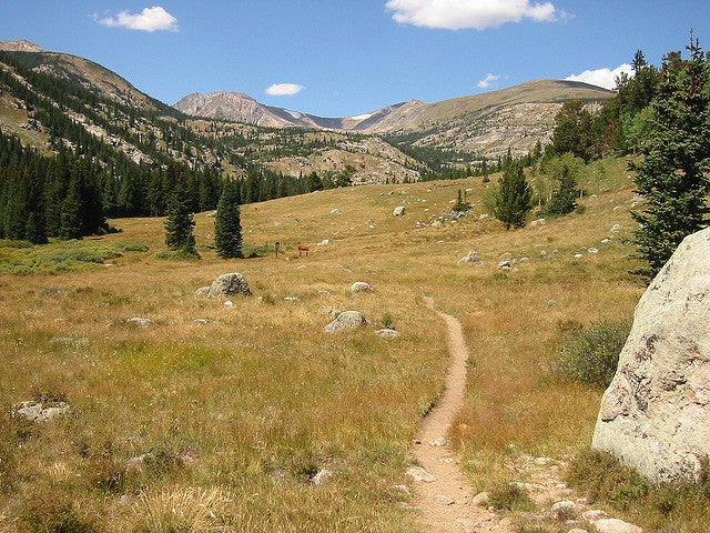
Staggering alpine terrain, an enticing web of backcountry trails, gemlike lakes strung beneath a crown of peaks—it’s no wonder hikers flock to Colorado’s Indian Peaks Wilderness all summer long, making it home to one of the most heavily used trail systems in the country. But come fall, the Front Range wilderness reverts to the kind of high-country retreat that drew all those people in the first place: a 73,000-acre parcel of Rocky Mountain highs where backpackers can find superlative scenery and solitude in equal proportions.
The catch? There isn’t one, unless you count the Rockies’ iffy fall weather.

One glance at the topo map tells you everything: Indian Peaks Wilderness, straddling the Continental Divide, delivers sky-scraping heights, broad valleys, and more than 50 alpine lakes. What the map doesn’t show you are mountainsides aglow with aspens turned gold, mountain lion tracks along the Sourdough Trail, golden eagles cruising the thermals over Paiute Lake, and black bears in the thick forests north of Arapaho Pass.
ADVERTISEMENT
My favorite autumn hike is the 15-mile Buchanon Pass Trail. From Peaceful Valley, the path climbs more than 2,500 lung-busting feet in its first nine miles, following the course of the glacier-fed St. Vrain Creek. Just more than seven miles out is the trout-laden Red Deer Lake. Backed by a perennial snowfield, the lake is beyond the range of most dayhikers, who you may encounter along the first few miles of trail.
Next up is the top-of-the-world terrain at Buchanon Pass, where you cross the Continental Divide at 12,000 feet. I always take a long break on the divide to try to identify all the sights on the near-limitless horizon. Sawtooth Mountain, a well-known Front Range landmark, lies just south of the pass, and the peaks of Rocky Mountain National Park and the Never Summer Wilderness stab the sky to the north. To the east, Boulder Valley rolls out toward the High Plains, and Gourd Lake and other sparkling alpine ponds light up the land to the west. The only thing missing from this flawless vista is the crowds of summer.
Indian Peaks Expedition Planner
DRIVE TIME: The Buchanon Pass trailhead is 32 miles (about 1 hour) northwest of Boulder.
THE WAY: For the scenic route from Boulder, take Boulder Canyon Road west to the town of Nederland. Then go north on CO 72 to Forest Service Road 114, the access road for Peaceful Valley Campground (to the west, 5.5 miles north of Ward). Turn left and proceed 1 mile to the trailhead.
TRAILS: The Buchanon Pass Trail runs 15 quad-burning miles from Peaceful Valley to its junction with the Cascade Creek Trail. Camp at Gourd Lake and retrace your steps, or connect with the Pawnee Pass Trail for a longer loop.
ELEVATION: The area ranges from 8,700 to 12,000 feet if you don’t bag any peaks (the wilderness area tops out at the 13,500-foot North Arapaho Peak).
CAN’T MISS: Twelve-thousand-year-old relics of the last Ice Age, seen via a 3-mile detour on the St. Vrain Glacier Trail.
CROWD CONTROL: The wilderness area’s quota system (and crowds) end on September 15, after which your chances of solitude steadily improve.
GUIDES: One good source is Map #102, Indian Peaks: Gold Hill (Trails Illustrated, 800-962-1643; www.trailsillustrated.com; $9.95). A free USDA Forest Service guide to the Indian Peaks Wilderness is available from the Boulder Ranger District. Also helpful is Colorado’s Indian Peaks: Classic Hikes and Climbs, by Gerry Roach (Fulcrum Publishing, 800-992-2908; www.fulcrum-books.com; $16.95).
WALK SOFTLY: In the spring, wait until the trails have melted out. Stick to lower elevations and avoid wandering off the footpaths.
CONTACT: Roosevelt National Forest, Boulder Ranger District; (303) 444-6600; www.fs.fed.us/r2/arnf.