Published October 12, 2010 05:06PM
50-Mile Thru-Hikes: Loyalsock Trail, Pennsylvania
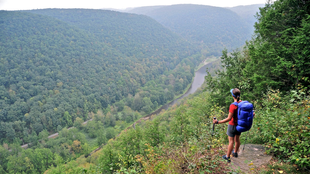
A 59-mile "long trail" through Pennsylvania.
(Photo: Cavan Images via Getty Images)
Unexpectedly and abruptly, at around mile 30, we run into a group of backpackers in their mid-20s. They are from West Chester, Pennsylvania, and they’re the first people my buddy Alan and I have seen in days. They smell like shampoo. They seem to be in a hurry.
“How far ya’ going?” one says.
“How many miles to Angel Falls?” asks another.
The trail chatter snaps me out of a thru-hiker’s hypnosis—I’m not sure what time it is or exactly where we are on the map. My mind has been floating and drifting, pleasantly void of stress or boundaries as my feet pad methodically through mile after mile of hemlock and hickory laced with rushing creeks. This is long-trail bliss.
ADVERTISEMENT
The crazy thing? This “long trail” is only 59 miles end to end, and we’re already about halfway through. Our trip isn’t a traditional multi-month, foot-long-beard-growing, trail name-acquiring, complicated-mail-dropping, job-quitting thru-hike. My friend Alan and I have families, careers, and mortgage payments that can’t be put on hold for six months. But we also have aspirations for long-trail satisfaction—accomplishment, adventure, scenic variety, disconnection, and the bone-weary exhaustion that rewards a hard effort. The solution: a point-to-point hike of about a week. By passing the aches-and-pain break-in period of the weekend, getting to know one trail intimately, and hiking into new territory, we hope to arrive at a place where contemplating the fuzzy caterpillar crossing the trail is infinitely more important than deciding whether granite or engineered stone countertops will better enhance resale.
Judging by the looks on the twentysomethings’ faces, our lofty plan appears to be working. They move on while I’m still trying to pinpoint our precise location.
Alan and I are on the Loyalsock Trail, a little-known route through the Nowheresville of north-central Pennsylvania. The path rolls and dips along the Allegheny Plateau in the heart of one of the biggest green blobs Google Earth shows south of Maine. The scene past the trailhead, near Hillsgrove Township, is straight out of the Carboniferous Period. A colony of fledgling ground pines—Joshua tree-like evergreens—projects weird lime-green antennae skyward. Stands of spruce, their arching branches studded with needles, cast shadows on an understory of spongy, star-shaped mosses. It’s a fascinating prologue, but we didn’t linger.
“We better get moving if we’re going to finish this thing,” Alan had said.
ADVERTISEMENT
The Loyalsock is diverse. It visits 31 waterfalls, countless drips and runnels, and one impressive set of class IV rapids. It pings to this beaver pond, pongs to that clearing, then shoots into an open forest of tall maple and black cherry underplanted in ferns nipped with autumn gold. The variety creates the illusion of covering more ground than we’d thought possible, a point driven home as Alan and I take out the maps while relaxing beside a small fire at a campsite in Dutters Run. We listen to a five-foot waterfall and play rewind on our adventure.
“Wow, still 32 miles to go?” I point out while tracing my finger back along the squiggling red line. “Perfect.”
“That climb right there was a killer,” adds Alan, jabbing a finger at the map. “And there’s where we got the apples off that old tree.”
But the best is yet to come. Going west to east, the Loyalsock’s highlights go from high to higher. The valleys are deeper, the streams more acrobatic, and the views more extensive. Fans of the trail are divided in pinpointing its apex. For some, it’s the collision of seven mountain ranges at Canyon Vista, at mile 43 in World’s End State Park. For others, it’s the Haystacks at mile 57, a sandstone outcrop in Loyalsock Creek that forms a snowmelt-charged, class IV+ rapid that kayakers paddle in spring.
ADVERTISEMENT
I say it comes at mile 34 at the head of Ketchum Run, where the trail teeters between darkness and light. Cupped in a west-facing bowl carved into steep hillsides, the east and west branches of translucent Ketchum Run converge in an intimate glen. It’s made dusky even at midday by steep walls of schist and a dense canopy of hemlock. Licks of cool air and the muffled roar of Lee’s Falls below drift up on a breeze. And there’s a campsite, too.
Debating a trail’s best spot can start a campfire brawl. But as we descend the final two miles, alongside Loyalsock Creek, I recall that sweet spot by Ketchum Run and realize that only one truth matters: You can never be sure until you’ve hiked the whole thing.
Contributing editor Jim Gorman vows to thru-hike the Pacific Crest Trail before he leaves this earth.
Hike It
The elevation profile (below) of this 59.2-mile trail looks like an EKG of arrhythmia as it cuts through the Endless Mountains region of north-central Pennsylvania, part of an immense deciduous woodland that spans the northern tier of Pennsylvania and southern New York. Target four to six days for a thru-hike gaining 12,000 feet in elevation.
ADVERTISEMENT
From the trailhead on PA 87 (1), climb nearly 1,300 feet in two miles to ledges at the lip of the Allegheny High Plateau, an ancient uplift worn to a 2,000-foot-high nub by glaciers. Quickly descend into rocky Pete’s Hollow, losing all of that hard-won elevation. Then it’s right back up again to hawk’s-eye views of the Loyalsock Valley from atop Smith Knob (2) at 1,850 feet.
The next seven miles gain minimal elevation, passing through open forest of cherry, hickory, and gray birch, and paralleling several small creeks. Make it an 8-, 11-, or 12.5-mile day by picking from excellent campsites beside mountain streams at Painter (3), Shingle, and Grandad Runs, respectively. The Loyalsock continues its mercurial ways, dropping off of the Allegheny Plateau, then regaining the heights on a three-mile walk on Genesee Trail Road (4). The dirt road follows the Towanda Path, an Iroquois trade route later used by soldiers in the War of 1812, and runaway slaves.
Pass remnants of an old resort (5) built to take advantage of superb views of pastoral valleys and forested ridges at the brink of the Allegheny Front. Lunch in open fields at mile 19, near the trail’s high point (2,140 feet), before entering a section of steep climbs and beautiful waterfalls, creeks, and views. Soak tired feet in crystalline Ogdonia Creek before the rapid ascent to the .3-mile spur trail to 80-foot Angel Falls (6). Continue north for two miles to Kettle Creek, where you’ll be tempted to camp next to the water but can’t; you’re in a protected natural area. Dutters Run (7) makes a fine consolation prize, with four waterfalls and several streamside campsites scattered over a half-mile.
ADVERTISEMENT
Next morning, hike 2.5 miles through woodland skirted with gardens of maidenhair, ostrich, and Christmas fern. The overlook at High Knob at mile 30 (8), one of 25 vistas, looks west down sharply cut Loyalsock Valley. Hike four rolling miles to a veritable water park of flumes, falls, and pools in Ketchum Run Gorge (9). From here, switchback up to Alpine View, which makes good on its name. Make your third camp at raucous Double Run at mile 39.7.
The next morning, after two miles of walking up knobs and grassy clearings, arrive at Loyalsock Canyon Vista (10) for views of World’s End State Park’s many deep ravines. From here, drop 600 feet to a bridge crossing Loyalsock Creek, followed by an 800-foot climb up the gorge’s other side. Hike east 2.5 miles to camping at Tamarack Run.
On the last day, recross Loyalsock Creek on an iron bridge to follow a railroad grade 1.5 miles until the trail returns to the river at the Haystacks (11), a class IV+ rapid in spring. Finish with a two-mile, hemlock-shaded riverside hike to the eastern terminus (12).
THE WAY West trailhead: on PA 87, seven miles north of Montoursville. East trailhead: .25 mile west of US 220 on Mead Rd., eight miles northeast of Laporte.
THE SEASON April for enhanced views through leafless trees, and October for vibrant fall colors (check hunting season dates with Loyalsock State Forest: 570-946-4049). Summers are hot and humid.