The Manual: Forecast the Weather

'oct 2010 the manual weather 200x170'
There’s an old saying in the Presidential Range: “If you don’t like the weather, wait a moment.” Funny how that saying also crops up in the Sierra, the Rockies, the Appalachians, and most other mountain ranges. In the backcountry, weather can—and will—change quickly and dramatically. In our new book, BACKPACKER’s Predicting the Weather ($13, falcon.com), excerpted here, Lisa Densmore teaches you how to read the skies for safer, drier outings.
Elemental Ingredients
- Air temperature While ground temps determine the number of layers you wear, the mercury up high dictates whether you’ll need raingear. As warm air rises, it cools off and approaches its dew point (the temperature at which water vapor turns to droplets). Heavy droplets then fall to earth as precip.
- WindThe stronger it is, the colder it feels (e.g., a 30°F day with 30-mph winds feels like 15°F). For a windchill chart, go to backpacker .com/windchill. Wind also signals change.
- Humidity Relative humidity (RH) is the amount of moisture in the air divided by how much water the air can hold at that temp (times 100). So an RH of 100 percent means the air is saturated (aka, at its dew point), and rain is coming. High humidity makes cold feel colder and heat hotter, via conduction. As air rises and cools, relative humidity increases.
- Barometric pressure This is the weight (per unit area) that the air exerts on the earth. A warm air mass is always lighter (less dense) than a cold air mass, and thus exerts less pressure. If the barometric pressure is falling, a warm front is coming in. If the barometric pressure is rising, a cold front is approaching.
Figuring Out Fronts

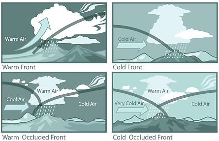
Colliding air masses are known as fronts. Like one car rear-ending another, the incoming front—typically from the west in the northern hemisphere—rams into the outgoing front, pushing it eastward. The faster the new front, the more violent the collision and the stormier the resulting weather. There are three types:
Warm fronts
A warm air mass arrives and rises slowly above the cold air ahead and gradually cools to its dew point.
Signs Low barometric pressure, high humidity, low cloud ceiling
Result Fairly calm winds (max speed of 20 mph) at the front’s leading edge; steady rain for days
Cold fronts
Fast-moving, unstable cold air pushes under the warm air ahead, forcing it up quickly and cooling it. Heavy rain might result.
Signs High barometric pressure, high cloud ceiling, good visibility unless precipitation is present
Result Fair weather that can change quickly; strong winds, generally from the north or west; and severe but brief thunderstorms or snow squalls
Occluded fronts
A battle royal of three air masses. A fast-moving cold front overtakes a warm front, lifting (occluding) the warm air mass. The incoming cold front then collides with the departing cold air mass. If the incoming cold front is warmer than the departing one (a situation dubbed a warm occluded front, WOF), the new cold front climbs over the exiting one while trapping the warm front high in the middle. If the incoming cold front is colder than the departing one, it wedges under it (aka, a cold occluded front, COF).
Signs Wind direction changes, usually so it blows from the north-northwest; falling, then rising barometric pressure
Result Storms possible; light to heavy rain followed by dry weather after the front exits. With WOFs, cold temps get milder; with COFs, cold temps get even colder.
Prevailing Patterns
Mountains In a process called adiabatic cooling, air cools by 5.5°F for every 1,000 feet of elevation gained (if there’s no moisture). Add humidity, and the rate slows to 3.2°F per 1,000 vertical feet. This can create precipitation on a peak even if the plains below are dry. Also: Wind flows upslope during the day as the air heats up, then downslope in the cool evening. So the earlier you summit, the less windy and cloudy it likely will be. Still, widespread clouds or strong prevailing winds can neutralize mountain effects.

Valleys Since cold air sinks, valleys are usually cooler than surrounding hillsides.
Ocean, sea, or lake It takes a huge body of water to impact the weather significantly. Water changes temperature more slowly than land, so during the day, breezes blow inland as air flows from the colder water toward the warmer land. At night, gusts travel from the cool land toward the warmer water. Thick clouds cancel this effect because they prevent a significant temperature differential between the lake or sea and the land. So coastal wind on a cloudy day signals an approaching front and likely a storm.
Glaciers and snowfields These create downslope breezes that travel about a third of a mile below them.
Deserts One big weather danger here? Thermals: columns of rising air that occur over hot spots on land or water. Air rushes to fill the column’s low-pressure zone, spawning sandstorms with up to 75-mph winds. Thermal action builds during the day, making sandstorms more likely in the afternoon. They also interfere with electronic transmissions like cell phones and radio. Wear goggles, a windshell, and a bandanna over your mouth and nose; seek shelter.
Test Your Meteorological IQ
Which of these old wives’ tales are accurate and which are bunk?
- Tornadoes never occur in the mountains. T/F
- The sky’s color at sunset predicts the weather. T/F
- Geese won’t fly before a storm. T/F
- You can predict a fair day with a cup of coffee. T/F
- Songbirds sing louder just before a storm. T/F
- Springs flow faster when a storm approaches. T/F
- Counting cricket chirps tells you the temperature. T/F
- Smoke rising straight signals a fair day tomorrow. T/F
- Sound travels farther when a storm approaches. T/F
- If the wind dies suddenly, it’s about to pour. T/F
Click here to see how you did.
Altitude Check
If your altimeter shows a rise in elevation even though you haven’t moved, it means the barometric pressure has fallen and a low-pressure storm system has arrived. A fall in elevation signals rising barometric pressure and an incoming high-pressure (good weather) system.