Published August 29, 2008 07:44PM
Next Level: Navigate Cross Country
3 key skills for getting off the trail without getting off course
'(Illustration by Supercorn)'
Study your lines
Before leaving the trail, practice reading topo maps on a route you know well, advises Jason Poole, a national champion orienteer who competes in 24-hour off-trail races. Match contour lines to familiar terrain, and you’ll understand how landmarks look on the map: Summits are bulls-eyes, rivers and valleys make tight V’s pointing upstream, and ridges create nested U’s pointing downhill. The closer the lines, the steeper the slope. Maps with small scale (1:24,000) and tight contour intervals (40 feet in mountainous terrain) are more accurate navigation tools.
Keep your place
Follow your position on the map by checking it every couple of minutes, says Poole. Look for cliffs, valleys, trails, and rivers. Use peripheral features as “handrails” to maintain your heading, and frontal elements (like a stream crossing) as “catching features” to mark your forward progress. Stuck in a forest with no sightlines? Note if you’re ascending or descending and confirm that your slope corresponds to the map’s contour lines.
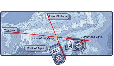
Mark your spot
Lost? Find yourself by triangulating your position using visual landmarks and a map.
- Before taking any bearings, adjust your compass for the local declination (the difference between magnetic and true north). For help, see backpacking 101.
- Hold the compass in your palm and point the “direction of travel” arrow at a unique feature, like a peak. Rotate the dial until the orienting arrow aligns with the red needle (known as putting “red Fred in the shed”). Take your bearing from the index pointer.
- Align the compass on the map so that magnetic north matches vertical grid lines.
- Move the compass so its edge runs through the peak. With the orienting arrow aligned with the magnetic arrow, draw a line along the edge to where you think you are.
- Shoot a bearing for a second landmark and plot its line on the map. Your position is where those lines intersect. The closer the angles are to 90 degrees, the more accurate the point position.