How to Predict the Weather

'Cumulonimbus Clouds'

Cumulonimbus Clouds

Nimbostratus Clouds

Cirrus Clouds
Cumulonimbus | Nimbostratus | Cirrus
Cumulonimbus clouds
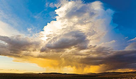
How they form When the sun heats up a moist air mass, or when a cold front wedges underneath it, that mass can rise violently upward—think afternoon thermals rising over the Rockies or a low-pressure front rolling into the Smokies. As the air rises, its water vapor condenses, lifting the cloud even higher. The result: massive thunderclouds piled miles high.
What to expect Cumulonimbus clouds can develop in as little as 20 minutes. The faster, taller, and darker they build up, the faster and more violent the energy release. Translation: fierce downpours, wind, lightning, and hail. In North America, thunderstorms are most common over the Florida peninsula and Colorado’s southeastern plains, but they also form commonly on the windward side of mountain ranges; above unevenly heated terrain; and wherever two air masses collide.
Warning signs Watch for altocumulus (mid-level, puffy clouds), especially in warm weather. These typically signal a cold front; once it collides with warm air, afternoon thunderstorms might result.
What to do Cut short your outing, descending from high points or jagged terrain and avoiding isolated, tall objects, like lone trees. If there’s lightning, spread 50 feet away from others, squat on top of insulating material, with your head down, feet together, and arms wrapped around your legs (for a safer lightning path in case of a strike).
Cumulonimbus | Nimbostratus | Cirrus
Nimbostratus clouds
How they form These sheets of gray and white blanket the sky—the quintessential cloudy day (the word stratus is actually Latin for “layer”). They form when a relatively stable air mass (read: not very different in temperature from the air around it) condenses over cooler air.
What to expect Prolonged rain or snow is likely. The lower, thicker, and darker the cloud, the sooner the precipitation.
Warning signs First, high, faint cirrostratus clouds create a haze across the sky and a halo around the sun, hinting at rain or snow within 24 hours. The cirrostratus might then lower and thicken into altostratus clouds, obscuring the sun’s exact location and suggesting continuous precipitation within 12 hours. If the altostratus clouds descend farther, they become dark nimbostratus clouds, which entirely obscure the sun and often produce steady precipitation that can last hours or days. What to do Gauge if you need to bust out miles to reach a campsite or cross slick terrain (say, a scree field) before the interminable drizzle.
Cumulonimbus | Nimbostratus | Cirrus
Cirrus clouds
How they form Found more than 20,000 feet high, these curly, wispy clouds consist of ice crystals and can form in any season. Cirrus generally appear white but, at dawn and dusk, can take on a rainbow of colors.
What to expect Fair weather
Warning signs Don’t confuse cirrus clouds with other high-altitude clouds such as cirrostratus clouds or high, lumpy cirrocumulus clouds. The former signal a good chance of rain or snow within 24 hours, and the latter often indicate cold weather; in the tropics, however, cirrocumulus clouds might mark a hurricane’s approach.
What to do Milk the weather window: Enjoy a long lunch or tack on another objective.