Updated July 8, 2025 11:57AM
Homemade Map Masterpiece
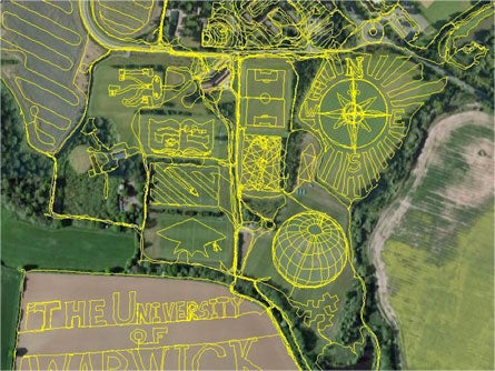
British student uses GPS to meticulously map his campus, and the result is awesome
While we here at BACKPACKER typically highlight GPS usage in the wilds of the Great Outdoors, we’ve found something so completely awesome that we want to give a shout-out to one of the most-innovative uses of GPS we’ve ever seen.
Jeremy Wood, from across the pond in the United Kingdom, created a masterpiece of GPS mapping in his Traverse Me map of The University of Warwick campus drawn on foot at 1:1 scale. This drawing is composed of 238 miles of GPS tracks walked over 17 days.
From the cartographer himself:
“My shoes turned brown in the dry fields and they turned green in the long grass. The compass rose and the globe were paced out over cricket pitches, and the scale was measured along a narrow tractor rut. I collided with objects and buildings, barriers and footpaths, and traipsed over the tops of multi-story car parks. Security was called on me twice on separate occasions, and I lost count of how many times I happened to trigger an automatic sliding door.”
Now that’s we call local hiking!
ADVERTISEMENT
Ever made your own map? Send it to us and we’ll throw up the best ones on the Daily Dirt. If you need help getting started, check out Bruce Barcott’s primer from May’s Map issue.
—Andrew Matranga, Map Editor