Published June 25, 2008 03:12PM
Highest Carbon Emissions in Rural West
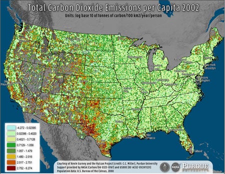
Though the wildest parts of the Western U.S. stand as mascots for environmental protection, the residents who live nearby hide a dirty little secret: Rural westerners have the biggest carbon footprint per capita in the U.S., according to data released by Purdue University. Purdue University researcher Kevin Gurney created the map above (click here for high-res), illustrating exactly where our carbon emission hotspots are. Areas of red indicate the highest emission zones, while greener zones reflect communities with smaller carbon footprints. Gray areas reflect areas without sufficient data; these areas are generally unpopulated.
Purdue works on a joint Purdue-NASA carbon emissions team called Project Vulcan. He measured his data by confining it to 10 by 10 kilometer squares, and while his measurements aren’t exact, they provide a great general idea and visual framework to analyze problem areas for carbon emissions. West Texas appears home to the biggest concentration of high-emission communities. Tsk, tsk, Texas.
While we may want to visit scenic places in the rural west, the map seems to bear out the fact that we shouldn’t live there — especially if we want to keep those landscapes from changing drastically in the near future.
— Ted Alvarez
Project Vulcan
Via High Country News’ GOAT blog