Navigation: Lakes and Oceans
Triangulate, forge through wind, and learn the tides with these water-bound navigation tips.
NAVIGATE:Forests/Mountains |
Whiteout/Darkness/Fog |
Canyons/Deserts |
Off-Trail
clutch skill
Master the Rule of Thumb
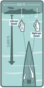
Even if you can see your destination across a broad lake or bay, gauging its distance is tough. That info is critical, however, in the face of changing tides, incoming storms, or impending darkness. You can estimate the mileage to a landmark—such as a cliff, island, or the mouth of a bay—using your thumb.

1. Determine the landmark’s width using your map (for example, a 600-foot-wide island). Now, with your right eye closed, stretch out your arm and hold your thumb upright so its right edge lines up with the right side of the landmark. Then close your left eye and open your right one; note how far the right edge of your thumb moved to the left. All the way across the landmark? Halfway? Twice as far?
2. The distance to that landmark is about 10 times the distance that your thumb shifted—thus, the phrase “rule of thumb.” (The reason: Most people’s arms are 10 times longer than the distance between their eyes, which, when you work out the geometry, yields the rule of thumb.) If your outstretched thumb moved halfway across the 600-foot-wide island, your distance away is about 3,000 feet—600 divided by two, times 10. Depending on the individual, the factor may be closer to 11 or 9, but your estimate will still be in the ballpark.
Triangulate Your Position
With a map and compass, you can pinpoint your position on a lake or bay. First, grab a true bearing on a landmark you can positively identify on the map—say, a lighthouse at 300 degrees. Draw a long, 300-degree line through the landmark. (Notice the line could also be considered a 120-degree line. This is called the back bearing—300 minus 180 equals 120.) Repeat this with another landmark, ideally about 90 degrees apart from the first. Where the two lines intersect is your location.
Beware Erratic Tides
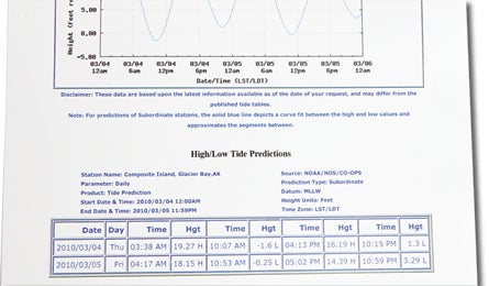
For a coastal hike, don’t rely solely on the tide table from the nearest harbor; the time and height of tides may vary dramatically along a coastline. And although most of the world’s tides are semidiurnal (two highs and two lows, about the same height, every 24 hours), some coastlines differ. Along Nootka Island in British Columbia, the two daily lows may vary by five feet or more. Inquire about local variations with the Coast Guard or marine outfitters, or download tidegraph.com’s nifty iPhone app.
Hug the Curves
In fast-moving water, stay to the inside corner on blind turns, to avoid getting washed into logs, trees, and other debris on the outside bend. The current also tends to be faster on the outer edge, assuming similar shorelines and uniform water depth across the channel at the turn. (If the water depth isn’t uniform, the current is typically slower in shallow water.) Need to dock? Look for back eddies, which will push you shoreward. They tend to form downstream of protuberances.
Forge Through Wind
If you’re paddling toward a landmark but wind or current keep pushing you off-course, try lining up one landmark with another visible object on shore, ideally one behind the other. Keep the two landmarks in the same relative position (to each other) to stay on track. Also, if traveling against prevailing winds, plan to paddle in the early morning or early evening, when winds are typically the calmest. Even a 10-knot wind can decrease your paddling speed by 20 percent.
Key Gear
1. Get the latest tide charts at tidesandcurrents.noaa.gov. To print them, use weatherproof paper from waterproof-paper.com/weatherproof-paper.html (also good for printing maps). $26 for 50 8 1/2 x 11 sheets
2.Osprey’s Map Wrap is a waterproof, trifold case that attaches to your pack’s shoulder strap, giving you quick-draw access without the worry of water damage; it tucks out of the way when you’re on the move. $15; 3 oz.; ospreypacks.com
3. The waterproof and durable Brunton 58 Kayak Compass straps directly to your vessel with elastic cord clips for easy, hands-free navigation. It is also a cinch to remove quickly when docking your boat. $78; 4 oz.; brunton.com
Photos by Courtesy and Julia Vandenoever (Tide Chart), Illustrations by Supercorn.


